Note sheet

What is Topography?
The definition, height details of a map.
What does the topographic map tell you, that other maps can't?
It tells you elevation and flat or tall surfaces.
Farmers might use a topographic map to know where is the best place to grow crops or for fire fighters to know which places have the highest chance of a fire.
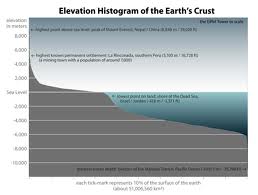
Elevation is the height of a plane relative to a reference height.
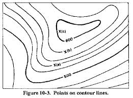
Contour lines are a line connecting points that have the same elevation.
Contour interview is the differences in elevation between two adjacent contour lines.
Depression Contour are contour lines indicating a downward slope (drawn with hatch marks).

